Quick tour of the browser
Page last updated: Monday, May 08, 2006 22:41:37 -0700
Contents
- Overview
- Context
- Thumbs viewer
- Image viewer
- WebMap (Google Maps) plugin
- InfoBrowser plugin
- Flickr plugin
- Google Earth
Overview
Users browse their photos and related information while telling or composing stories of their personal life experiences, all the while maintaining an idea of time, place, and people. Stories consist of more than answers to the simple questions When? Where? and Who?, but that information provides a framework from which a rich narratives are created. Virgil is a photo browser that allows a user to browse his personal photo collection and related information while maintaining and exploiting the current context (time, location, and personal identity).
The first time you run Virgil:
- Add one or more photo folder paths in Edit -> Preferences
- Execute Admin -> Scan for new. All jpeg photos under each folder will be scanned, thumbnails computed, and recognized properties extracted (including EXIF and IPTC).
- The progress bar at the bottom of the application will indicate how many photos have been processed and how many are remaining (hover the mouse over it for precise information).
- Halt the background thumbnail scanning any time with Admin -> Halt background tasks; the thumbnail view will be updated immediately. The next scan-for-new will only process photos not found already.
- When complete you will see your photos automatically clustered by time. Time clusters are shown in a hierarchical tree view on the left, while corresponding thumbnails are shown on the right.
- Digital photos that were not created by a digital camera, or are from an old digital camera, do not have reliable timestamps. If no internal timestamp is found, Virgil will use the file system's last modified timestamp for the file. Some digital cameras also allow the time to be zero if the clock has not been set. Virgil will place any of these photos in a special time cluster labeled "No timestamps". A future update of Virgil will include functionality to generate valid timestamp properties.
NOTE: Virgil will never modify your original photos.
Context
The overview mentions that Virgil maintains a current context of time, location, and people. Any plugin can change the current context or respond to changes in it, and the changes can be to any part of the context (e.g., just time or just location). The context indicator is a control (a plugin, too) visible at the top of the application that always displays a summary of the current context:
![]()
To the left are the starting and ending times of the current time range. To the right are the total number of photos and the number of them that are selected. In the middle is the location, including a text description from Microsoft's TerraService as well as the latitude and longitude. (Any of this text can be selected, dragged & dropped to annotate a photo).
Thumbs viewer
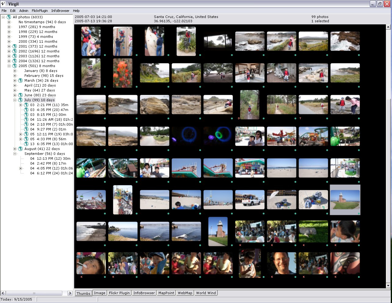
The Thumbs tab shows time clusters on the left, and corresponding photo thumbnails on the right. It will scroll quickly through thousands of thumbnails.
- Click on a time cluster to include only those photos in the view.
- Properties can be added to photos by dragging and dropping text, links, or images from a web browser onto a thumbnail.
- Double-click a thumbnail to open the photo in a full-screen viewer. Once in the full-screen viewer, use the left and right arrow keys (or space and backspace) to move to the next and previous photos, and press ESC to exit. Right-click for a context menu that provides access to some image properties.
- The thumbnail size can be changed in the User Preferences (Edit->Preferences, or F9). You should remake any existing thumbs if you want their resolution to reflect the new setting.
- A green globe icon is shown for any time clusters that include one or more geotagged photos (geotagged means it has a location property). A small green circle is shown to the lower right of each thumbnail that has a location property.
- The Thumbs tab is minimized to a single row of thumbnails when the other tabs are selected.
Each thumbnail may display one or more markings below it. The letters T, D, and K indicate title, description and keyword(s) respectively, while a green dot indicates a location.
Image viewer
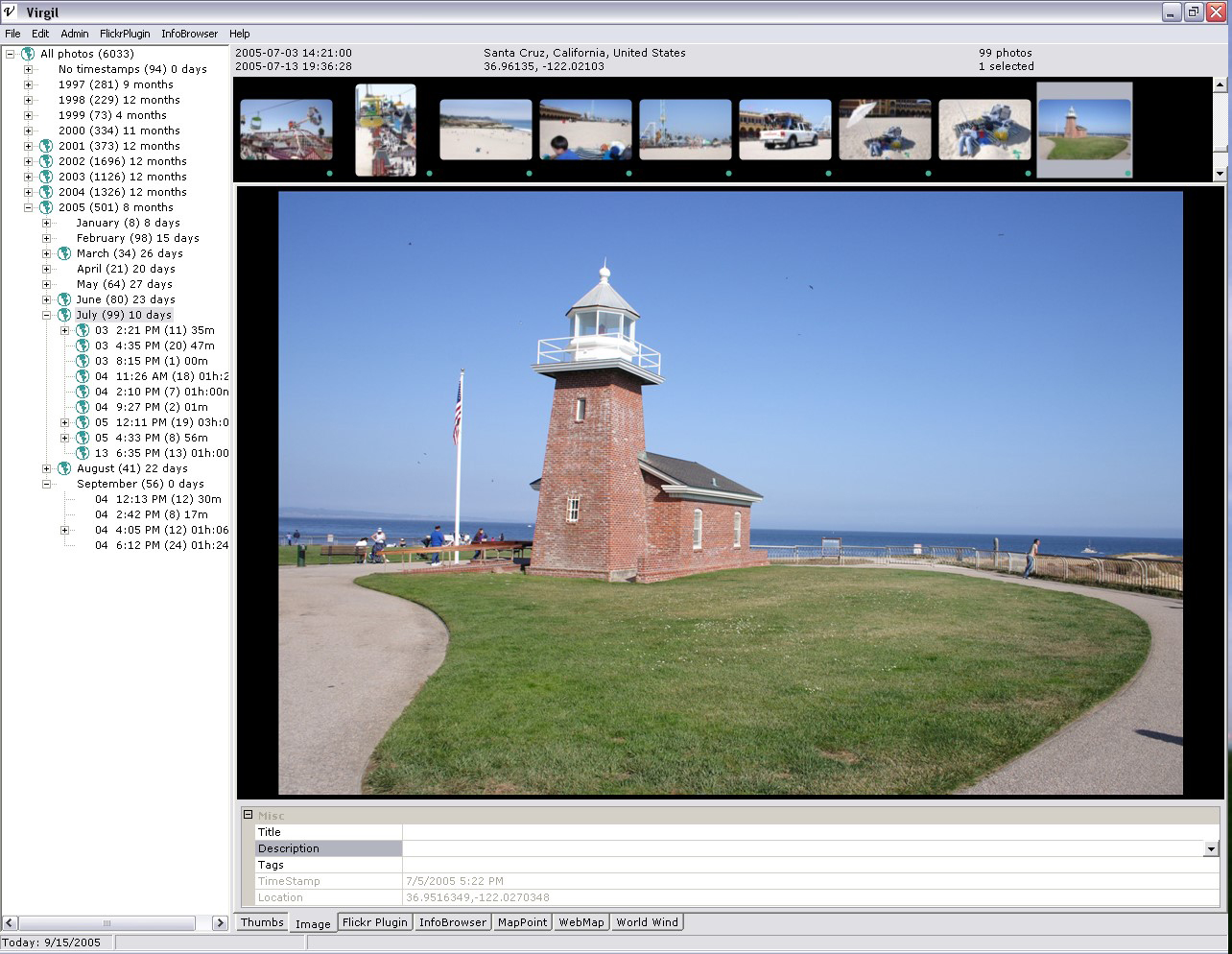
The image view above shows the current photo above a list of its properties.
- Properties can be added using drag and drop onto a thumbnail, the image, or the property list.
- Double-click on the main image to open the full-screen viewer.
- Currently the Timestamp and Location properties may not be manually edited.
- Change the photo by clicking on a different thumbnail or time cluster.
- If no thumbnail is selected, the first photo in the time cluster is chosen.
- If multiple thumbnails are selected, the first photo in the selection is chosen.
WebMap plugin
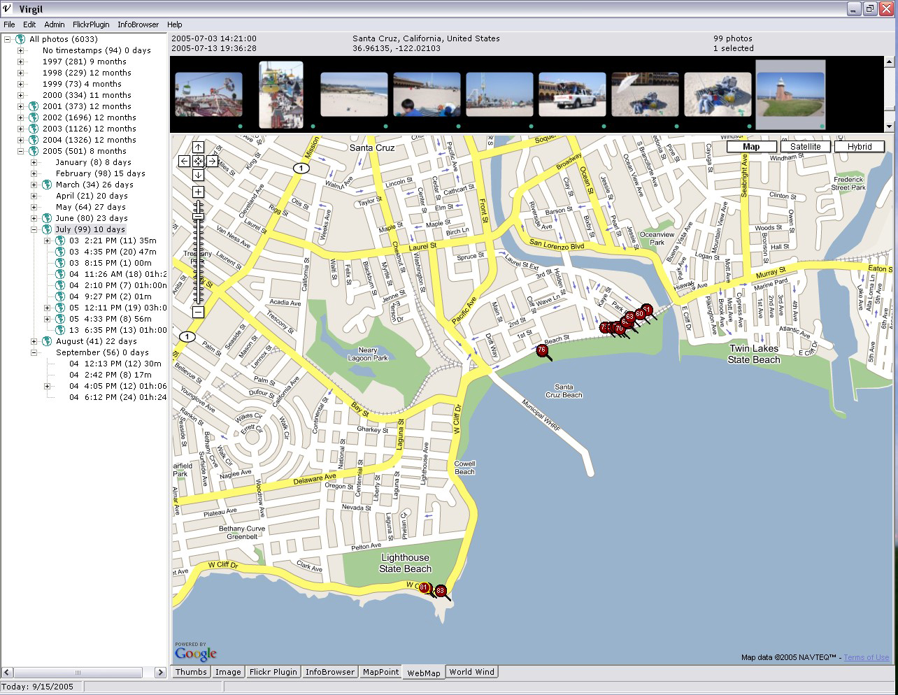
This plugin uses the Google Maps web service to map geotagged photos and to provide a visual method to assign a location property to one or more photos. The map view will update dynamically to reflect the current Virgil location context, which in turn may be set by selecting a geotagged photo, time cluster, or via another plugin.
- A red circle is plotted for each geotagged photo. The circles are numbered to indicate the temporal order of the geotagged photos only; they do not necessarily correspond to the thumbnails as some may not have a location property.
- Clicking a circle highlights it, and selects and scrolls the Thumbs control to the corresponding photo.
- Right-clicking a circle shows a context menu offering more options: center map on this location, and open in Google Earth.
- A location can be assigned to one or more selected photos by centering the map (double-click on desired location), then Edit->Assign location (or Ctl-L).
- Locations can be assigned in bulk from a GPS tracklog recorded while the photos were being taken. The "Admin -> Import tracklog" command can be executed when any tab is visible, and is not constrained to the current photos. Note that locations can only be assigned to photos that are already managed by Virgil; the tracklog is not stored by Virgil for use with photos that are added later.
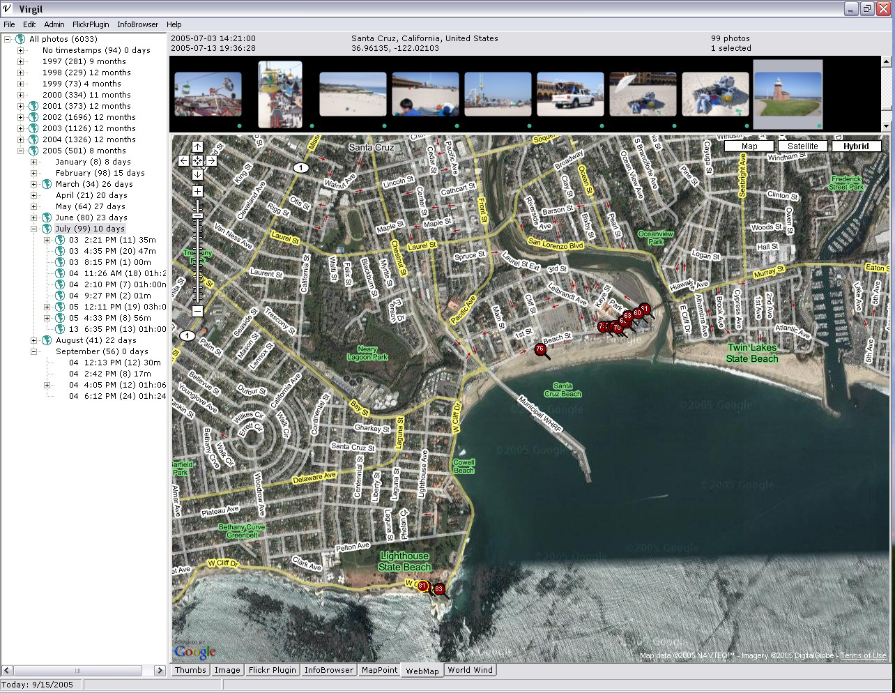
- Use the built-in Google Maps controls to zoom in and out, click & drag to pan, or to switch modes between road, satellite, and hybrid views.
Below is a sample of the hybrid mode:
WebMap bugs that I'm working to fix:
- Don't click on the Terms of Use link at the lower right of the map; it will cause an error and this plugin will stop working (the rest of the app is OK).
- The map position can get out of sync with the POI circles. If any circles are visible, right-click on one and choose to center on that location. Or switch to a different time cluster and back. Either of those actions should get it back in sync.
InfoBrowser plugin
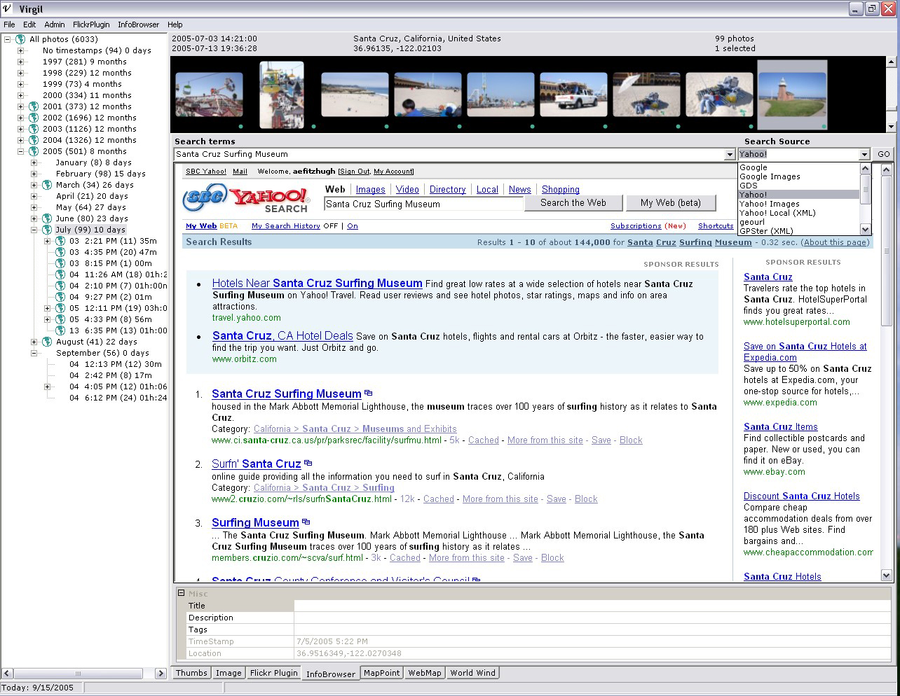
The InfoBrowser plugin tries to automatically find information on the web that is related to the current photo. It constructs queries automatically based on the current context.
- The Search terms pulldown shows names of points of interest, in order of proximity, obtained automatically from the Microsoft MapPoint web service.
- The Search Source specifies from where to get related info. Choose Yahoo! Images and you'll see others' photos of the same place as yours. Choose Geocaching.com and you'll see geocaches located near the current location.
- The MapPoint database is not perfect, especially in remote areas. In those cases you might see completely uninteresting POI names, such as Bob's Auto Repair, etc. Also, the POI searches only work in North America, Europe, and possibly Australia due to MapPoint limitations.
- The Search Sources are user configurable and can include Virgil metadata using macros. Use {TERMS} to insert the value of the Search terms. Use {LAT} and {LON} to insert the latitude and longitude, respectively, of the current photo. See the existing search sources in Edit -> Preferences -> Search tab.
- Photo annotation is simple: as you find relevant information, just drag and drop title and/or description text from the web page to the thumbnail or property list. (It is not currently possible to annotate multiple photos at once.
- Searches are executed automatically when the InfoBrowser tab is selected, when the Search terms or Search Source selections are changed; or when the GO button is pressed.
Flickr plugin
This plugin demonstrates how an online photo service can be integrated with Virgil. Flickr has an open web API and metadata support that helps Virgil to exploit the current context (time, location, person) to make discovery of related information simple.
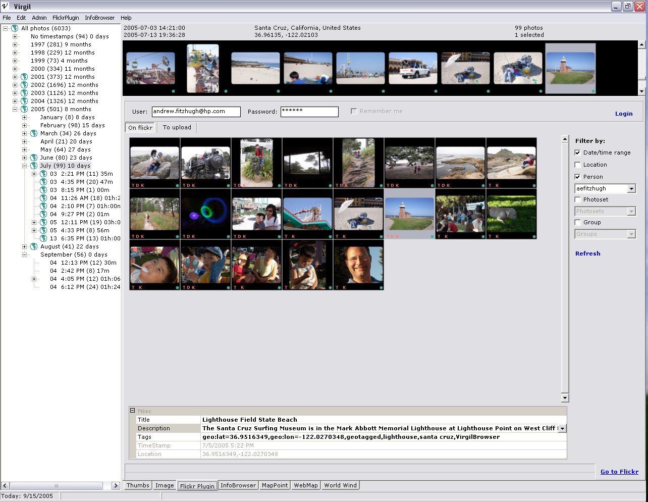
As the Virgil context changes, matching results from Flickr will be updated dynamically (subject to the filter settings on the right). This plugin makes it simple for multiple friends or family members to find and retrieve each others' photos that correspond to a shared experience.
The upload tab allows the user to collect local photos from the Thumbs control by dragging and dropping Virgil thumbnails. Each photo's properties can be reviewed and modified, the online Flickr permissions can be specified, and then they can be uploaded to the current Flickr account.
Notes:
-
Virgil adds some Flickr tags automatically: "geotagged", "geo:lat=xx.xxx", "geo:long=xx.xxx", and "VirgilBrowser".
-
Flickr does not support server-side location searches; location searches will likely fail unless you limit them to a single person and a reasonably short time range.
-
Flickr is still a beta service, particularly the programmatic API. They will disable certain kinds of complex searches at times to keep the rest of the site performing well. You can definitely try some of those complex searches via this interface :-).
-
Filtering by photoset and/or group are not implemented yet. In addition, the pulldown lists will always show your own photosets and groups, not those of the currently selected contact.
Google Earth
As noted above under WebMap plugin, if you right click on a POI marker in the Google Maps view you can choose to view the photo locations in Google Earth. This allows dynamic 3-D browsing of the world via high resolution aerial and/or satellite imagery.
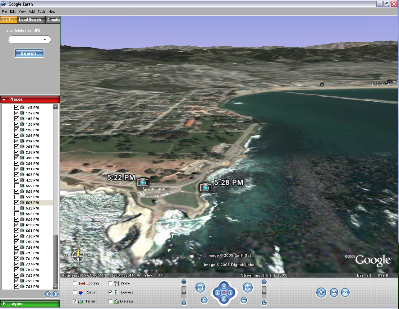
Virgil creates a temporary .KML (Keyhole Markup Language) file containing all the geotagged photos in the current context, and then Virgil has Windows open the file with the currently registered handler for .KML files. The free, basic version of Google Earth works fine for this purpose. Google Earth will pan to the average location upon loading the KML, and the photo locations will be marked with camera icons. Some metadata is included in the POI markers, but no image thumbnails (yet).
There is a plugin for NASA's World Wind that embeds the application within Virgil, but it has certain limitations (it does not plot photos in the world, and it consumes a lot of CPU and memory).